


Humminbird with the GR-50 Receiver we will see offers outstanding accuracy for standard Equipment Receiver on all Internal and External Receiver in the 700, 800, 900 and 1100 Series Units. A 50 Channel Receiver can maintain a lock on 50 different satellites at a single time which allows for faster acquisition of location and maintaining the lock on the satellites as they begin to leave the horizon and pick up new satellites as they start rising in the horizon. The more satellites the higher the accuracy level to calculate your exact location time after time, year after year. The GR-50 when hooked direct into the unit will provide 4 Times per Second Refresh Rate of your location which allows for faster direction changes and tracking your exact location.
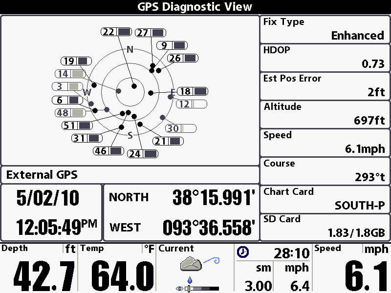
Here is a Screen Capture of the GR-50 the other day tracking 17 Satellites at one time:
Here is the Current Satellites Planned and Orbiting From the 3 Northern Hemisphere Constellations.
US Constellation: 32 Satellites with 28 Useable
GLONASS (USSR): 24 Satellites Planned with 20 Useable
Galileo (European Union): 30 Satellites Planned and 2 Useable
This data was the most recent I have been supplied, may be more satellites available.
On the GPS Diagnostics Screen one thing I like to look is HDOP Calculation. This is the Horizontal Dilution of Precision which is the measurement of the contribution of satellite geometry to the uncertainty in a position fix. The lower the number the better. Here's a refence chart to valves and relevance of the GPS Data:
1: Ideal - This is the highest possible confidence level to be used for applications demanding the highest possible precision at all times.
1-2: Excellent - At this confidence level, positional measurements are considered accurate enough to meet all but the most sensitive applications.
2-5: Good - Represents a level that marks the minimum appropriate for making business decisions. Positional measurements could be used to make reliable in-route navigation suggestions to the user.
5-10: Moderate - Positional measurements could be used for calculations, but the fix quality could still be improved. A more open view of the sky is recommended.
10-20: Fair - Represents a low confidence level. Positional measurements should be discarded or used only to indicate a very rough estimate of the current location.
>20: Poor - At this level, measurements are inaccurate by as much as 300 meters with a 6 meter accurate device (50 DOP × 6 meters) and should be discarded.
How to Find the Accuracy of your Humminbird
The GPS Diagnostic View can tell you alot about the performance of your GPS Receiver and the Reception you are receiving. To get to the GPS Diagnostic View you can access it through the Start-up Menu or the easiest way is to go into the Master Menu (Hit Menu Twice) then scroll with 4 Way cursor over to View Tab. Hit Up Arrow on the cursor and towards the bottom you will see the GPS Diagnostic View and status will be Hidden. Turn it on to Visible. (See Pic Below)
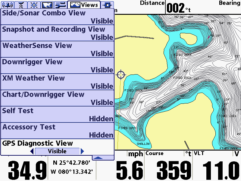
Now page through the VIEWS to get to the GPS Diagnostic VIEW. Hitting VIEW will page forward. EXIT will page backwards through the VIEWS. It will look like the Image Below.
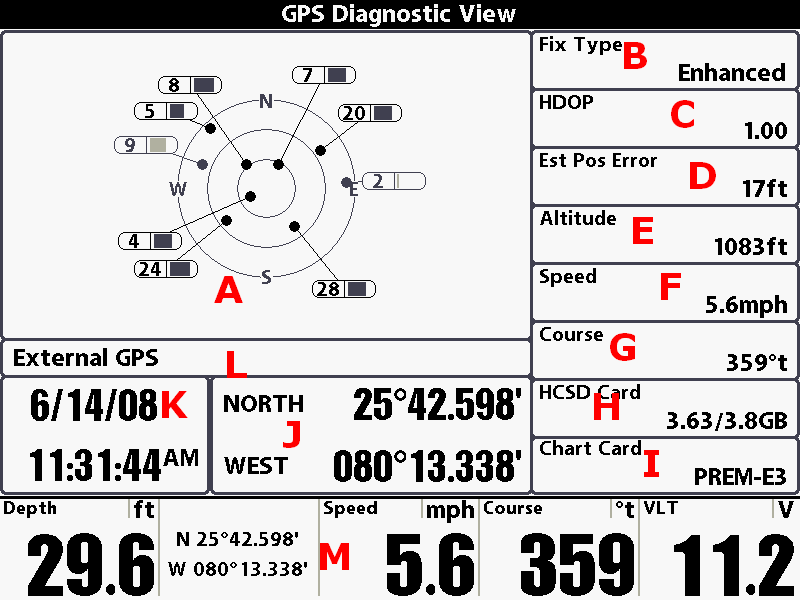
So what does all this mean and how do I use it? We will go through each letter and explain what it is and what it does.
A: The "Bullseye" tracks the satellites and tells you signal strength of each one. Depending on the Channel of GPS Receiver you have you may see more or less. GR-4 tracks up to 4 Satellites, GR-16 up to 16 Satellites and the new Standard Equipment on many models the GR-50 can track up to 50 Satellites. The Bar Graph next to each number tells you signal strength. THe darker the number the stronger the reception. This correlates to the distance the satellite is from the center or your location. The more satellites near the center or represented in black the better the postion or accuracy to mark your location.
B: Is the type of fix you are getting. No Fix, 2D Fix, 3D Fix or Enhanced. Enhanced is the highest level. Enhance uses correction data from WAAS, EGNOS or MSAS to help increase position accuracy. A 3D or Enhanced Fix is need for Navigation.
C: HDOP or Horizontal Dilution of Precision. Is a value for the current position of the satellites used to calculate accuracy. The lower the number the better the accuracy. Humminbird usually shots for 0.6 to 3 for best accuracy levels. Here is some good reading on Wilkipedia: http://en.wikipedia.org/wiki/D...PS%29
D: Estimated Position Error is the estimated distance the current position is off from being exact. Humminbirds average is less than 2.5 Meters or 8.2 Feet.
E: Altitude is the calculated height of the GPS Receiver above sea level.
F: Speed: Is the GPS Calculated speed
G: Course: Is the direction the boat is heading. 0/360 Degrees is straight North, 90 Degrees is East, 180 is South and 270 is west.
H: Left Card Reader Slot. In this example I have a HyCapcity SD Card with 3.63 GB of 3.8 GB left for storage.
I: Right Card Reader Slot: In this example I have a Navionics Premium East Card installed and the unit recognizes it.
J: Current GPS Position
K: Time and Date from the GPS Receiver
L: Type of GPS Receiver the Unit is Using
M: Selected Readouts. These are the user defined readouts that are displayed in all VIEWS. I have Depth, Position, Speed. Course and Volts selected.
FYI: GPS Satellites transmit the time and date and the receiver uses the time and date information to calculate the distance from the satellite. This is how GPS position can be determined by receiving multiple Time and Date Transmissions and calculating the position on earth compared to satellite location and time and date.
Hope this helps you understand the relationship and performance differences between the different GPS Systems available for recreational use Plus how to know the accuracy of saving waypoints and returning precisely back to them.
---
I just got off the phone with some GPS Specialist that I know. One being the Resident GPS Expert at Humminbird to get the answers which you requested and end without a shadow of any doubt why I can track 17 Satellites with my Humminbird GR-50 Receiver.
All 3 Experts I talked with explained the US GPS Constellation is not symmetrical or spaced equally. Some satellites are in clusters or small groups, as you can see in the image below but still all help in locating position. They also stated that the advertised constellation is 24 satellites but right now there are from 31-32 active satellites in orbit that can be used to calculate your position. So Yes you can track over 12 satellites at certain periods of time in the current consumer US Constellation.
The reason for clusters or groups of satellites is because older satellites are being upgraded with new satellites and both the old and new satellites are both functioning at present time with accurate data to help in locating your position. They also stated that there are actually 3 WAAS Satellites orbiting right now. 2 (like advertised) are maintaining the intended track and a 3rd is in and out of service but can be displayed and provide position location as it becomes in service.
With consumer electronics the maximum allowable displayed trackable satellites are 18 but more can be tracked that are coming above the horizon or falling off the horizon but not displayed. If you look at the image below the light gray satellites are being tracked but the data is not being used at the present time to help establish position because they are outside the useable threshold Humminbird uses to help locate position. Other words until they reach a threshold that will help improve the accuracy that data is not figured in to calculate location but still being represented and tracked. When they reach that level they can add benefit to locating position then they will be represented in black.
The benefit to being able to track additional satellites is to increases the response to acquire position and it allows the GPS to maintain a higher level of accuracy as it can start tracking a satellite earlier as it rises above the horizon and hold on to it longer before it leaves the horizon. Having open channels allows for improved GPS performance.
I also was informed the Current Galileo Project by the European Union is not being used and only 2 Satellites are currently orbiting earth and the accurate track of these satellites are not valuable yet to improve GPS in locating your position. Glonass Project maintained by Russia is orbiting and can become available for civilian use in the near future but as of date none of the Glonass Constellation is being used in position location for Humminbird.
The Standard GPS Receiver from Humminbird is not only providing more as standard equipment but is prepared for expansion when new opportunities arise as more and more Position Satellites are added to the current Constellations and the use of other Constellations become developed.
Hope this helps you learn more about how your Humminbird GPS Performs.


 Advertising