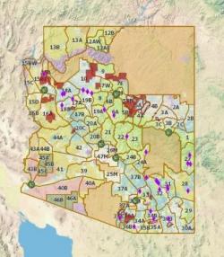
PHOENIX - The Arizona Game and Fish
Department has launched an exciting new web-based mapping tool,
"Recreational Access Arizona," that provides hunters, anglers, and
other outdoor recreationists with important information about access to and
through private lands.
The free tool, which utilizes GIS mapping technology, is available at www.azaccessmap.com.
Recreational Access Arizona was developed as part of the Game and Fish
Department's efforts to secure, maintain and enhance public recreational access
to private lands, or to federal or state-owned lands that are
"land-locked" by private lands. It provides a wealth of other
information as well.
Want to see the boundaries of the Game Management Unit you're in or where water
catchments are located? Are you interested in what wildlife species are in a
particular area? All the information is available with the click of a mouse
anywhere on the map. The more places you click, the more information you can
find.
To help get you started, just click on the "How to Use the Map" link
in the upper right-hand corner of the page after you've logged on.
Even more exciting is that you can create your own map using this tool with a
topographic map, aerial images, or street maps as the background. Just export
the map you make and print it out on your home printer, or take it in to a
printing service to print a large map.
Development and maintenance of this tool was made possible through a grant that
Game and Fish received from the Voluntary Public Access and Habitat Incentive
Program, which is a federal program authorized in the 2012 Farm Bill.
The department plans to add information that is useful to hunters and other
outdoor recreationists over time, so users are encouraged to use the "Send
Comments" link in the upper right-hand portion of the web page to e-mail
comments for consideration.
For more information, visit www.azaccessmap.com.


 Advertising