

The modern fishing electronics have changed the way anglers locate and catch bass. Fishing has turned into hunting as many anglers spend hours looking at their electronics before even making a cast. Professional anglers like Bassmaster Elite Series pro James Elam have found ways to both simplify and speed up the process of finding bass.
Sonar
The standard 2D Sonar may appear to have taken a backseat to new technologies like DownScan Imaging, StructureScan and StructureScan 3D, but it is still a very useful tool for locating bass.
“I leave standard sonar on my screen at all times at both the bow of the boat and at the wheel,” began Elam. “It is very useful when you are driving around and looking for fish.”
He uses it when he is both idling looking for fish and driving from spot to spot. “There are times when you will look down on your graph and see a high spot or sharp break that doesn’t even show up on your map,” he said. “You can then scroll back, mark a waypoint, and then idle over it to get a better look with your DownScan or StructureScan.”
Elam keeps things fairly simple when it comes to settings and doesn’t adjust anything from the factory settings. “The key is to spend some time with it so you know what you are looking for,” he said. “Sonar is a great tool to use when you are looking for changes of bottom composition and places that have grass. It’s perfect for finding those types of areas.”
DownScan
The DownScan technology really shines when looking for structure according to Elam. “The first thing to figure out is what type of cover the fish relate to in that body of water,” he said. “If fish are deep in grass or right in between big rocks, it will be easy to find the structure, but harder to make out individual fish.”
Brush piles are another story though as Elam says it is fairly easy to make out the “white dots” that represent fish sitting in the cover.
“DownScan is good for many situations, but is really best for finding fish on lakes that have current and fish stack up on drop offs,” he said. “It becomes really obvious to find those fish when they are grouped up like that.”
SEE WHAT"S NEW FROM LOWRANCE FOR 2017 HERE
StructureScan
StructureScan excels at searching vast areas for bass while idling. Elam is a big fan of using it to cover water during practice for a tournament. He will adjust his range based on the depth he is fishing, but generally a 40- to 80-ft range will suffice.
Split Screens
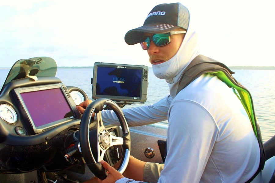
One of the benefits of using large graphs like the Lowrance HDS 12 is the ability to split the screen multiple times and still easily view each reading. Elam runs two Gen3 12’s at the helm and one up front. The way he splits each screen helps him see just everything that is important to him.
“I’ll split my screen up front with a three-way split and have the chart, DownScan and standard sonar visible,” he said. “At the wheel, I will have one split to the chart and sonar and the other will be split between DownScan and StructureScan.”
The final graph is split between DownScan and StructureScan and will be shown top and bottom instead of side-to-side. “This is really important because it gives you more history and you can scroll back to see things you may have missed or to get another look,” he added.
Waypoints, Trails and Mapping
One thing seldom mentioned is how the professional anglers utilize waypoints and trails to find fish and then to come back to them later.
“My approach to trails is really simple but it helps me so much when I am returning to an area,” said Elam. “I’ll use a different color trail for each day and that will let me know exactly where I was and if there are any areas I missed while fishing or idling looking for fish.”
The trails also help him greatly on offshore events where he is drifting fishing for smallmouth and then again when moving through vast expanses of grass.
“I’ll set a waypoint on the start of my drift or where I started to fish in the grass,” said the Lowrance pro. “This way if I catch one on that pass through an area, I will know the exact route I took. It just makes it so much easier to see where you have been and where you caught them.”
When it comes to mapping, Elam will adjust his chart settings to only show contours shallower than 30-feet deep.
“These units are fast, but doing this speeds it up so much,” he explained. “I am rarely focused on water deeper than that so it makes it easier to only focus on those contours.”
Adjusting settings and getting the most out of your electronics is one of the biggest questions many have when they get a new unit. By setting them up correctly and spending time with each technology, anglers will locate and find more fish.
 Advertising