

 A team of state agencies have worked together to develop an interactive map of stream restoration and fish passage projects in Wyoming.
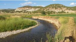
Cheyenne - A team of state agencies have worked together to develop an interactive map of stream restoration and fish passage projects in Wyoming. The map, published as a Story Map (available through Esri) can be found online.
Local, state, and federal partners have worked to implement restoration and fish passage projects across Wyoming. These projects have resulted in numerous benefits to Wyoming citizens, such as improved fisheries and aquatic habitat, cleaner water, more efficient irrigation systems, reduced erosion of agricultural land, improved riparian areas and terrestrial wildlife habitat, protection of roads and other infrastructure, and enhanced recreational opportunities.
Viewers are encouraged to use the map to learn about overall restoration and fish passage efforts in Wyoming, as well as to find examples of projects that may inspire and help guide further efforts in other parts of the state.
The team of state agencies was formed in response to initiatives established under Governor Mead's 2015 Wyoming Water Strategy. Participating agencies include Wyoming Game and Fish Department, Wyoming Department of Environmental Quality, Wyoming Water Development Commission, Wyoming Wildlife and Natural Resource Trust, Wyoming Department of Agriculture, Wyoming Department of Transportation, and the Wyoming Governor's Office. Additional resources developed by this agency team, such as funding resources, agency contacts, and tips for project planning, can be found on Wyoming Game and Fish Department's Water Strategy Website.
 Advertising
Copyright © 2013-2026 WesternBass.com ®