

New Autorouting functionality provides smoother, more detailed routes that are displayed within seconds on the Navionics Boating app for iPhone and iPad (coming to Android). It’s now easier than ever for boaters to plan their outings while onboard their boat, as the new functionality enables dock to dock route 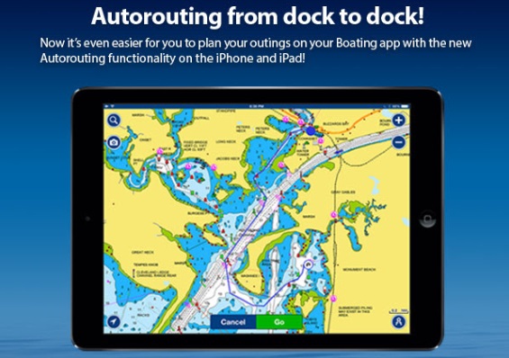 planning along US coastal marine, Great Lakes, and major river areas.
Autorouting is able to plot a course taking into consideration the boat settings, navaids, water depths and more. Boaters simply tap their start and end waypoints on the map and the app displays the route along with any precautions such as shallow water or collision avoidance, as well as speed, ETA, distance to arrival and total distance while underway. Now it is also possible to search geo-referenced points of interest such as marinas, waterfront restaurants, or enter latitude/longitude for any destination.
What do I need to use Autorouting?
- If you don’t already have Navionics Boating on your iPhone or iPad, download the free version and select your region with a one week free trial before you purchase (or if you prefer, get the paid app with the same features). If you already have Navionics Boating, just make sure it is updated to version 8.1.
- Tap Route>Automatic Route and Tap and hold the map to add waypoints; or use ‘search’ to select a point of interest or indicate a lat/long coordinate.
Autorouting is for general planning and reference only – it does NOT replace safe navigation practices and should never be your only reference source.
Navionics Boating is easily found on iTunes for iPhone and iPad, and Google Play for Android Handset and Tablet.
 Advertising