

 June 2015 — Global electronic chart provider Jeppesen has announced the release of C-MAP MAX-N+ 2015 cartography, delivering an improved navigation experience and enhanced fishing content for users of
Lowrance HDS Gen2, Gen2 Touch, and Gen3 MFDs. This cartography release has been timed to coordinate with the recent release of upgraded software from Lowrance, available at no cost to owners of these popular MFDs.
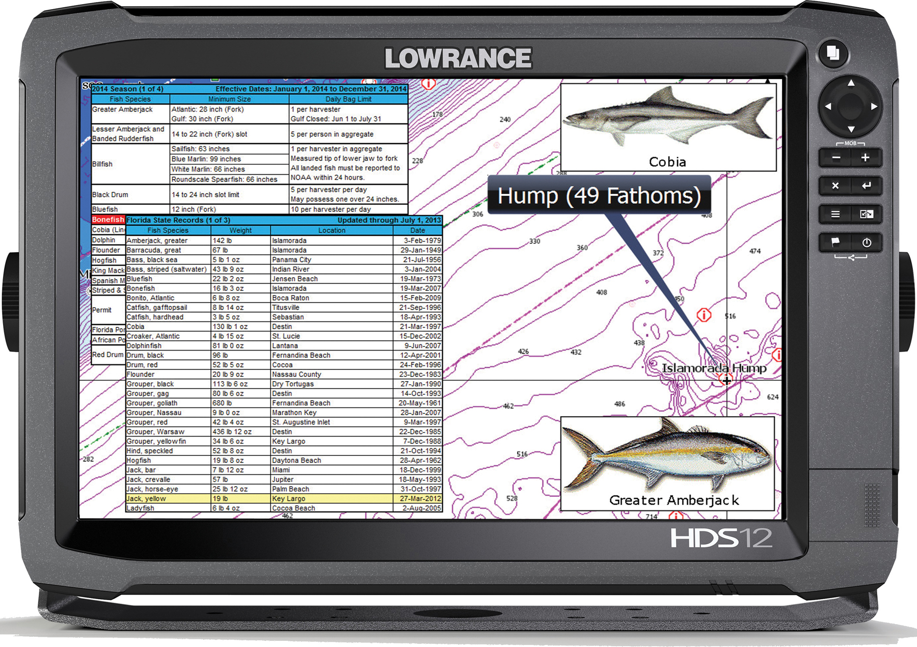
The release of C-MAP MAX-N+ 2015 cartography is a major update that brings the majority of the C-MAP 4D content and many of its features and functions to the C-MAP MAX-N+ 2015 product line, combining accurate, up-to-date global chart data with specific features and content developed for serious fishing enthusiasts. This includes Jeppesen’s library of High-Resolution Bathymetric (HRB) bottom contour data, now included with Local and Wide charts. These detailed contour charts help fishermen effectively target underwater pinnacles, ledges, depressions and other “structure” widely known to concentrate baitfish and predatory gamefish. In addition, Jeppesen’s exclusive Sport Fishing Data provides anglers with a wealth of useful information on wrecks and reefs, including composition, depth/orientation and other details, helping fishermen fine tune their presentation of baits and lures on the anchor, drift or troll. The Sport Fishing Data in MAX-N+ 2015 also features color Fish ID photos, localized sport fishing rules and regulations, and state angling records, putting important, regional knowledge at every angler’s fingertips.
MAX-N+ 2015 charts also give fishermen the latest boundaries and details for California’s growing network of Marine Protected Areas (MPAs), helping anglers fish adjacent to these productive marine habitats while observing important rules and restrictions. Another key MAX-N+ 2015 feature, Dynamic Tides & Currents, helps anglers time their fishing trips to take advantage of the best tidal currents over shoals, rips and points. Jeppesen’s worldwide database of Marina Info/Port Services and detailed aerial photos of harbor entrances, channels and marinas provide enhanced situational awareness and important information for tournament fishermen and other traveling anglers.
Boaters who want these and other new features found in MAX-N+ 2015 cartography must first take advantage of free software upgrades for their compatible Lowrance systems. These are available worldwide by visiting www.lowrance.com.
C-MAP MAX-N+ 2015 charts can be purchased through Jeppesen dealers worldwide on pre-programmed micro SD cards, or online through the Navico GoFree website at www.gofreemarine.com. Lowrance HDS Gen3 and Gen2 Touch owners can also take advantage of accessing the GoFree store via the MFD when connected to the internet. C-MAP MAX-N+ 2015 charts can be purchased and downloaded directly to the plotter.
Lowrance HDS-12 Gen3 with Jeppesen C-MAP MAX-N+ 2015 Sport Fishing Data
About Jeppesen
Jeppesen is a market-leading provider of vessel operations services and digital navigation solutions, based on worldwide vector chart data type approved to ISO19879, meteorological information and transmission technologies. Jeppesen offers a wide range of navigation and operations products and services to both recreational and commercial marine markets. Safety-conscious boaters and operators of vessels ranging from coastal to SOLAS class, rely on Jeppesen for innovative navigation solutions that improve safety and efficiency.
Jeppesen is a subsidiary of The Boeing Company. Jeppesen corporate information is available online at jeppesen.com.
About Navico: A privately held, international corporation, Navico is currently the world’s largest marine electronics company, and is the parent company to leading marine electronics brands: Lowrance, Simrad, B&G and GoFree. Navico has approximately 1,500 employees globally and distribution in more than 100 countries worldwide. www.navico.com
 Advertising