

Butano Creek Restoration Reopens Habitat for Salmon in California
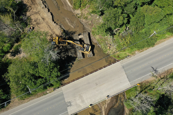
 Restoration work underway in Pescadero Marsh. (Photo: San Mateo Resource Conservation District)
|
FISHERIES
Butano Creek Restoration Reopens Habitat for Salmon in California
NOAA-supported restoration work aims to alleviate flooding, prevent fish kills, and reconnect migrating salmon and steelhead to their historic habitat.
For decades, sediment buildup in California’s Butano Creek caused an array of issues for both fish and people. It flooded roads and local communities, prevented steelhead and coho salmon from migrating, and contributed to substantial die-offs of fish. In October 2019, the NOAA Restoration Center and partners finished a $7 million effort to remove the sediment and restore the creek.
A Waterway in Crisis
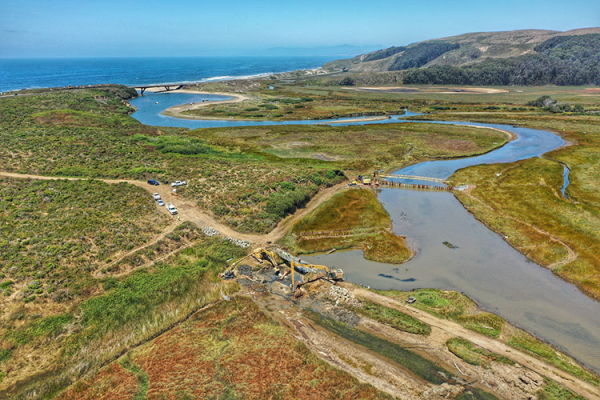
Butano Creek is a major tributary of Pescadero Creek. It winds through San Mateo County in central California, from its headwaters in the Santa Cruz Mountains to its mouth in Pescadero Creek Marsh. Decades of agriculture, logging and other human activities caused a huge increase in the amount of sediment entering the waterway. As sediment built up over time, it resulted in what was essentially a mile-long dam, clogging the flow of water and blocking the migration of fish.
This sediment buildup caused particular damage near the small town of Pescadero, where Butano Creek flows under the only major road in and out of town. Originally, Pescadero Creek Road bridge sat 14 feet above the water level of Butano Creek. As sediment built up underneath, clearance below the bridge shrunk to just a few inches.
During rainstorms, rising waters in the creek had nowhere to go but out—onto the road and into the community. Floodwaters inundated nearby farm fields and properties, blocked access to the road, and cut the community off from emergency services, schools, and highways.
Pescadero wasn’t alone in being cut off from a vital passageway. Fish like threatened steelhead trout were unable to bypass the barrier of sediment buildup. They lost access to more than 10 miles of habitat historically used for spawning, rearing, and refuge. Fish attempting to migrate further into the Butano Creek watershed were instead stuck near the mouth of the creek, in Pescadero Marsh.
Pescadero Marsh presented its own hazards for fish. Lack of oxygen in the water caused seasonal fish kills, in which dozens to thousands of steelhead would die each year. A combination of factors contributed to and worsened these oxygen-depleted conditions:
- Previously, Pescadero Marsh was a seasonal wetland that would dry out during the summer. With sediment blocking the flow of Butano Creek, water moving downstream would be forced to flow into nearby Pescadero Marsh instead.
- This meant the once-seasonal marsh was now wet year-round. As a result, vegetation could grow—and die and decay—year-round as well. The increase in decaying marsh vegetation led to a build-up of oxygen-depleted sediment in the marsh.
- When the mouth of Pescadero Creek would breach each year, the turbulent outflow of water would disturb the sediment. It would then engulf fish in a flood of toxic, oxygen-depleted water and sediment.
Blocked from migrating further into Butano Creek, many fish were left unable to escape these suffocating conditions.
Collaborating on a Solution
A range of partners worked for years to find solutions to these problems. With destructive flooding and fish kills happening every year, there was a critical need to embark on a path forward—and quickly.
Staff from the NOAA Restoration Center, housed within the Office of Habitat Conservation in NOAA Fisheries, stepped up. They led multiple federal, state, and county partners to solve the issues facing Butano Creek. These partners supported the formation of an expert panel to evaluate the issues and recommend a path forward. NOAA staff also served as leads on permitting, helping to coordinate and navigate federal, state and county processes. Our expertise and assistance helped permits get through more quickly—reducing the amount of time that potential fish kills and flooding might have continued occurring.
In 2017, the NOAA Restoration Center awarded the San Mateo Resource Conservation District more than $1.4 million. The funding, provided through the NOAA Coastal Resilience Grants Program, supported restoration work in Butano Creek. San Mateo County and the California Department of Parks and Recreation provided additional funding and support.
Restoration Gets Underway
In June 2019, the Conservation District began removing the sediment blocking Butano Creek.
Partners removed close to 70,000 cubic yards of sediment—enough to fill more than 20 Olympic-sized swimming pools. This reopened more than 8.5 miles of Butano Creek to migrating fish. The sediment was then used to fill in the deep trenches in Pescadero Marsh that had been releasing oxygen-depleted water and worsening the fish kills.
In addition, partners removed much of the sediment built up beneath Pescadero Creek Road bridge. Clearance between the creek and the bridge increased from just six inches to nearly nine feet. The sediment removal will not prevent all flooding from occurring. However, it is estimated to significantly reduce the frequency and duration of flooding in the town during small and medium-sized storms.
Looking to the Future
With post-project monitoring over the next few years, NOAA and partners expect to see decreases in flooding and fewer fish kills. Long-term, partners hope that endangered coho salmon—absent from Butano Creek for decades—may be able to return. NOAA Fisheries scientists estimate that, under the right conditions, Butano Creek and the rest of the Pescadero Creek watershed could support up to 2,300 spawning adult coho salmon.
 Advertising