


Navionics - What We Need to Know
Josh Douglas (above) and Miles Burghoff are two anglers who have been connected to Navionics for many years as they worked their way up the bass fishing ranks. Now, both are fishing professionally with FLW as both competed in this year’s Forrest Wood Cup after successful seasons on the FLW Tour. Now, they will both be part of the new FLW Pro Circuit next season.
With their years of experience with Navionics products and mastery of marine electronics, they each have a few ways that they get the most out of their mapping
READ RELATED: What's New in 2019 with Navionics
Zoomed In and Zoomed Out Mapping
Something as simple as zooming in or out a map can play dividends according to both Douglas and Burghoff.
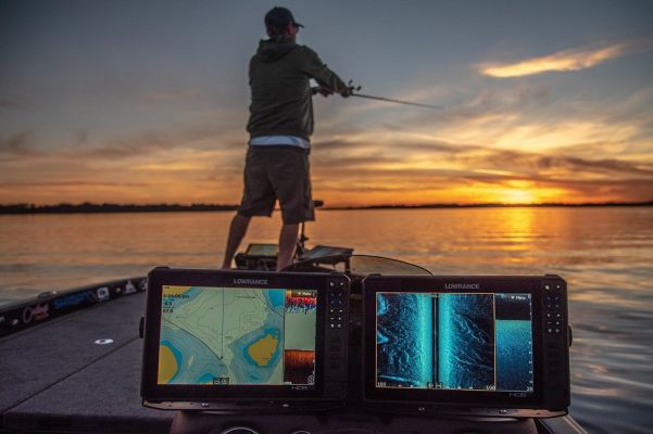
Douglas, for instance, likes to run the same map on a split-screen setup on his Lowrance units. One he has zoomed in close, and the other is zoomed out.
“With one card, you can share the mapping from one card to different units or on the same unit with a split-screen. I like to have one of them zoomed out to get the big picture of a lake, and when I am driving and navigating to different parts of the lake,” said Douglas. “By zooming in, you can get a detailed look at all of the contours.”
Burghoff has a similar line of thinking and does the same thing. “I like to call it ‘micro mapping’ where the map is zoomed in. This is what I use when I am idling looking for areas and looking for those intricate details,” he shared. “I also run my unit zoomed out and call that ‘macro mapping’ where I am trying to get a broader view of the lake at a glance.”
Watch Related: Weather and Tides Using Your App
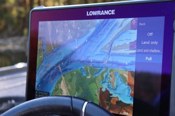
SonarChart Shading
The ability to turn on a shading feature is new to this year, and Burghoff is a big fan of what it allows him to see. The Navionics Platinum cards have this feature, and different shades of blue allow for a quick look at varying features on the bottom of a water body.
“The SonarChart Shading is a good way to get a snapshot of the contours of the lake. It takes out the guesswork,” Burghoff said. “You can easily see the steepest banks and the biggest flats in the lake. It cuts down the interpretation time.”
Burghoff typically runs this on his “macro mapping” that he referred to previously. He utilizes it with the map zoomed out while getting the big picture of a body of water.
READ RELATED: 6 Quick and Easy Steps to Map Live
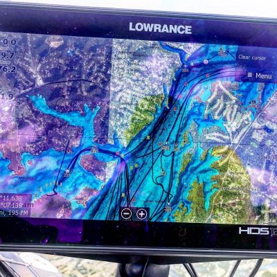
Navionics Boating App Colored Fishing Ranges
The Navionics app is the most popular boating app available for smartphones and tablets. Douglas loves his app and uses it on and off the water.
One of the things that he utilizes often is the feature that allows you to change colors for different depth ranges.
“It is so unique and helpful to use. And, everyone has a smartphone in their pocket so anyone can do it,” he began. “I adjust the ranges based on the depth I am fishing and the fishery.”
This feature allows you to customize whatever depth range you prefer to use, and it is available in several different colors. Douglas likes to choose contrasting colors to make the ranges stand out better.
“I try to make it contrasting with splashy colors. I’ll have a dark one, then a light one, and then a dark color. It pops when you do that, and it is amazing how much it helps,” he shared. “Even for someone like me who is so used to looking at Navionics mapping and looking for spots. Those little areas and unique places jump out at you when you add color.”
When he is fishing 20-feet or less, he uses smaller ranges. For instance, he might set 0 to 5-feet one color, 5 to 10-feet as another, and then do the same with 10 to 15-feet and 15 to 20-feet of water. “If I am fishing offshore or deeper water, I may have each range set for 10-foot intervals,” said Douglas.
Enabling SonarChart
One of the most common things that both Douglas and Burghoff are asked is about setting a unit to show SonarChart, which is 1-foot contours with Navionics. Just plugging a card into a unit will not enable this feature, and you need to make sure your electronics are set to show the best level of detail.
Burghoff is unique in that he runs both Humminbird and Lowrance on his boat. Each of these brands has a different way to enable this feature.
“On Lowrance, you have to enable SonarChart in the settings. On Humminbird, you hit the menu button twice and go to Chart Select,” Burghoff said. “From there, you have to select either ‘Left Fish’n Chip card’ or ‘Right Fish’n Chip card’ depending on which slot your Navionics card is in.”
Marine electronics are powerful tools and like computers rigged to our boats. By understanding what they are capable of and learning how to get the most out of them, you can speed up your time to break down a lake and find more bass with Navionics mapping. These tips from the pros should help make that process even faster.
 Advertising